ROUTE
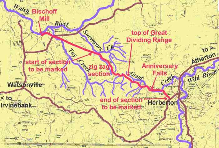
The track follows the shortest possible
route from the Bischoff Mill to Herberton. The Bar-Barrum people
claim that this same route was used by them to travel from what is now
the Herberton area to a former boora ground located in the Walsh Rver valley,
adjacent to the track. The topography of the route is distintive,
with the Anniversary Gully on the Herberton side and the Empress Range
saddle on the Walsh side acting as funnels. Anyone travelling from
the Herberton area to the central part of the Walsh River valley on foot
or horsback would have soon discovered this to be the quickest way.
The track started at the Bischoff
Mill and headed almost in a straight line east-south-easterly towards Herberton.
It crossed Toy Creek where the phone line presently crosses the creek adjacent
to the Walsh River Road. From there it crossed the back sections
of what are presently four freehold properties.
It then travelled in almost a straight
line, crossing the claypan and down to Surveyors Creek. It crossed
the Right Branch of Surveyors Creek just a few metres up from where this
branch joins the Main [Left] Branch.
View
map
The main climb to get the height
necessary to cross the Great Dividing Range was up the spur between the
Right and Little Right Branches of Surveyors Creek. The climb was
spectacular as it zigzagged its way up the spur with one cutting and
several sharp changes in direction. Unfortunately, this section was
severely damaged during one afternoon in 1985, when a bulldozer pushed
in an access road to service the towers for the high voltage power line.
The cutting is no longer recognisable although it is possible to detect
the zigzag in places.
The spur leads to the saddle in
the Empress Range distinguished by its transmission tower. The track
passed through the saddle about 200m east of the tower, then went around
the side of the Toy Creek crater, crossed Toy Creek above the crater and
then climbed to the plateau section of the Great Dividing Range.
This is where the range is crossed - being its lowest point in the
district.
View
map
Coming off the plateau the track
crossed two gullies, being part of the headwaters of Grant Creek, before
following a narrow gully down into Grant Creek itself. Grant
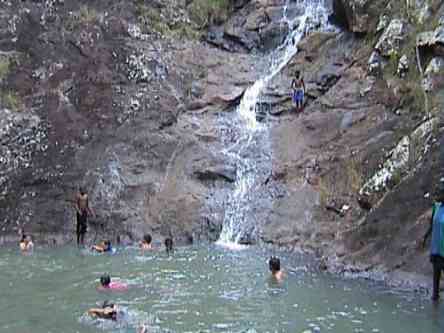
Creek is crossed four times. The third crossing is quite picturesque,
being at the top of the Anniversary Falls and affording an excellent view
of the falls and the swimming hole below it. From the falls
the track followed the Anniversary Gully past some of the finest examples
of stone pitching in the district and down onto the flat country and the
outskirts of Herberton.
The last section of the track went
down the gully adjacent to the present Herberton Hospital and it is still
possible to follow the track along this section almost to the Herberton-Petford
Road.
The track is 11k long.
Top
of Page